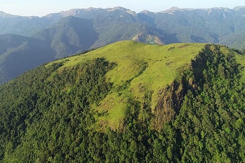
A satellite survey of the buffer zone of Ayyankovil Panchayat in Idukki district by the Kerala government has categorised the parcel of agricultural land owned by Babu Chempankulam as forest land. Babu, a 60-year-old farmer, who cultivates pepper, cardamom and coffee in the land handed over to him by his ancestors says his land may have appeared as forest since the human inhabitants are less.
Babu wants the government to not go by satellite survey alone while determining the characteristics of the land and to run a check on the ground before boundaries are demarcated. Farming in the region is already facing a crisis and asking farmers to stop cultivating their land on the basis of the satellite survey would impact them severely. The survey is being opposed by residents and farmers for the lapses in identifying dwellings and clusters located inside protected zones. The state government, however, has taken the stand that the survey report is not final.
The Supreme Court had said last year that every protected forest, national park and wildlife sanctuary in the country should have a minimum one kilometre eco-sensitive zone (ESZ) from their demarcated boundaries. The judgement referred to the guidelines on buffer zones issued by the Ministry of Environment, Forest and Climate Change (MoEF&C) of the Government of India on February 9, 2011. The judgement had evoked apprehensions in Kerala with the farmers fearing that this would affect their livelihood because of the farmland’s proximity to the areas that would come under the buffer zone. Ecological buffer zones are protected areas established around sensitive areas. These areas include wetlands and wildlife breeding habitats. Buffer zones are marked to ensure no damaging activities are carried out in the area and to lessen the impacts of human activity and disturbances to the ecosystem.
The Kerala government recently released a report of the satellite survey that covered several hectares of human habitations and farm land in some panchayats of the state. While the report has evoked discontent among various farmer organisations, the opposition Congress has accused the government for wasting time and resources on the satellite survey which was ‘hastily ‘done.
The Opposition objection is also because the government did not carry out a manual survey of areas which may fall in the one-kilometre buffer zone around protected forests and wildlife sanctuaries. The Forest Minister has maintained that the satellite survey report won't be submitted in its present form before the Supreme Court or the Union government. The government has also sought help from all departments concerned to come out with a comprehensive report which can be placed before the apex court and the union government.
Chief Minister Pinarayi Vijayan called a high-level meeting on the issue on December 20, attended by ministers and officials of the departments of Revenue, Forest, Finance and Local Self Government. The decision to hold the meeting came hours after the Congress announced that it would be holding public agitations on the issue across the state. The CM has also taken stand that the satellite survey report is not final.
Babu Chempankulam says, “How the problem of farmers will be discussed in a high level meeting with officials who are not aware of the ground reality?
“Why was there no proper discussion on the issue at the recently concluded Assembly session?” asks Babu Chempankulam. The farmers have already been suffering due to the attack of wild animals and because of the low price for produce, he said. “We are not even able to educate our children the way they want to,” said Babu.
The Kerala Catholic Church has also come out against the government in support of the farmers and local communities who are likely to be impacted by the proposed buffer zone.
”We oppose the survey report because it is unscientific. For example, in the 33rd ward of the Kattappana Municipality in Idukki, out of the 325 houses 300 come under the buffer zone as per the survey. Areas on the other side of the river that have farmlands and are inhabited by around 500 people are also shown as part of the buffer zone as per the survey,” says Prasanth Raju, chairman of the Kattappana Municipality, ruled by the Congress. His demand is to exclude human habitations from buffer zones, no matter if the survey is a manual one or a satellite one.
The Kattappana Municipality has been collecting tax receipts from families whose houses have been mapped under the buffer zones to prove that the survey was not properly done.