Subscribe
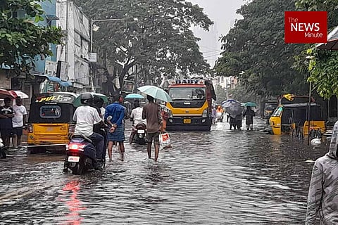
A new, crowdsourced flood map of Chennai shows that among over 250 localities in Chennai, which saw intensive flooding during the November rains this year, many neighbourhoods were unusually flooded. This includes neighbourhoods such as T Nagar, Alwarpet, Egmore which have remained unaffected by monsoons in the previous years, barring the 2015 Chennai floods.
The map was prepared by a city-based NGO called Care Earth Trust, by crowdsourcing data from residents across Chennai. The NGO created and circulated a form to collect information on the neighbourhoods flooded in the city. It included queries such as location or neighborhood, street name, approximate level of waterlogging, level of waterlogging during the time of rains and post rains, date of peak flooding, present status of location (whether still flooded) etc. Based on the responses, the map was developed by the team under Stephen Jayaseelan, the GIS Cell Head at Care Earth Trust. The map is colour coded, with the areas marked in a darker blue showing intensive flooding.
“We received about 900 responses to the forms. On sifting through the forms, we found out that there were multiple complaints/responses for the same neighborhood or street. Finally, using 250 unique responses, we mapped the intensively waterlogged areas of Chennai from November 7. We are still collecting responses, and will further make iterations to the map,” says Dr Jayshree, Managing Trustee of Care Earth Trust. The map, which will be available in the public domain shortly, shows big neighbourhoods such as Tambaram, Kodambakkam, Kundrathur, Chrompet, Selaiyur, Teynampet, Porur, Ashok Nagar, Velachery, Koyambedu. Annanagar etc. among flooded localities.
“We generally see that places in north and south Chennai are very prone to water logging. For example, areas like Velachery are affected during rains every year. However, what was an anomaly is that some central Chennai neighbourhoods which are not usually affected by the monsoons were flooded,” Dr Jayshree adds. This includes T Nagar, Alwarpet and Egmore, Dr Jayshree adds. Care Earth is studying the reasons behind flooding in these areas.

Care Earth Map showing flooded localities of the city
According to Dr Jayshree, unsustainable buildings and encroachment of wetlands are the overarching trigger and the root cause of flooding in the city. However, there are several additional problems which need to be addressed to mitigate floods, she says. “For this, the government needs to do a detailed field survey and address local triggers. Ditch the city-based flood proofing plan. I don’t believe it will work in a city like Chennai, as every neighbourhood has its own issues and flood triggers. The state government or civic body needs to draft a zone-based flood proofing plan for all 15 zones in Chennai,” Dr Jayshree adds.
Citing an example, she says that the flooding in T Nagar due to the November 7 rains was caused by a local trigger. “T Nagar is not a place that gets flooded every time. But this time, several parts of T Nagar – including Pondy Bazaar, Bashyam Road and GN Chetty road, which are the roads identified for area based development under the Smart Cities Mission – were completely under water,” she says.
In T Nagar, debris dumped along a 1.7-km stretch along the Mambalam canal is what triggered the floods, blocking the water from draining into the Adyar river. The debris was from the canal restoration works under the Smart Cities Mission. After this local trigger was identified, the Chennai Corporation officials cleared the debris and expanded the canal, draining out the water from these roads. The Corporation also halted the Smart Cities Mission work temporarily.
Under the #Chennai #SmartCity ‘96 bridge’ #TNagar #ChennaiRains pic.twitter.com/GmDSWZDQaZ
— Shabbir Ahmed (@Ahmedshabbir20) November 22, 2021
Apart from the canal blockage, poorly built storm water drains too contributed to T Nagar flooding. This too is an example of a local trigger, Dr Jayshree adds. Parts of T Nagar witnessed water logging again on Monday, November 22, following rains.
T' nagar still flooded. Deplorable civic conditions. @chennaicorp @ChennaiRains pic.twitter.com/Ag7nVX5sna
— KALPANA SUNDER (@KalpanaSunder) November 22, 2021
Scenes from T.Nagar now... @GSBediIAS @CMOTamilnadu @arivalayam @chennaicorp pic.twitter.com/FBnqzgsKmd
— Sangeetha Kandavel (@sang1983) November 22, 2021
The NGO will release two more map series – the first, a timeline mapping floods in Chennai in 2005, 2015 and 2021; and the second, a set of maps identifying the zonal triggers for floods in the city.
“The first is going to be a time series of flooding in the city from three different years. 2005 is when we worked on collecting data during flooding in Kalakutai, Velachery. Then in 2015, we collected detailed data and prepared flood maps for Chennai, to show the increase in built up area and decrease in wetland area in the city. The next maps series will look at changes and patterns from the 2015-2021 period” Dr Jayshree says.
For the maps on zonal triggers, Care Earth’s team is conducting field assessments and zone-to-zone surveys and also received responses from residents as part of its data collection and mapping process.
If you would like to contribute to Care Earth's map, click here to fill out the form.