Subscribe
On October 29, 2019, Climate Central – a US-based climate think tank – released a report that has just made climate change shockingly real, immediate and local by confirming what activists have been saying for long. Using a highly accurate digital elevation model (DEM) assisted by machine-learning, the organisation’s scientists have established that earlier models – based on NASA’s Shuttle Radar Topography Mission (SRTM) – had underestimated the extent of low-lying lands along the coast.
The CoastalDEM used by Climate Central pegs the total number of people living in areas that will be affected by annual ocean flooding at 30 crores (300 million) by 2050. Of this, 75% will be in Asia – China, Bangladesh, India, Thailand, Indonesia and Vietnam.
36 million people in coastal India will be affected by coastal flooding and inundation as a result of sea level rise, even if moderate cuts in CO2 emissions are undertaken. Unlike floods due to rains, coastal flooding leaves long-lasting damage – permanent damage if the events happen annually. Sea level rise will cause salinisation of land, damage to built structures due to corrosion, water scarcity due to salinity intrusion into freshwater aquifers, and outright destruction to critical infrastructure like ports and harbours, roads, and coastal power plants and desalination plants.
Metropolitan cities like Kolkata, Chennai, Kochi and Mumbai are set to take a bad hit, if the model’s results are to be believed.
Indian GIS experts like Raj Bhagat Palanichamy have pointed out that the current model too suffers from errors that may overstate the impact of sea level rise and associated inundation and flooding.
He advises “extreme caution” when the document, the methods and data are used in local context, suggesting that “It’s better to do ground surveys for projecting the risks in these places.” He concludes that “Alarmist false positives are as bad as false negatives.”
One should not resort to falsehoods to cause alarm. However, the “Precautionary Principle” states that one does not have to wait for conclusive proof of harm before taking action to protect oneself. The Government of India and its people do not appear prone to alarm. In fact, we seem to be remarkably alarm-proof. Even as global science came out with shocking revelations about the extent of climate change-induced sea level rise, the Ministry of Environment, Forests and Climate Change diluted the coastal protection rules – where the earlier rules prohibited construction within 100 metres of the High Tide Line, the new rules notified by the Ministry downgraded that to 10 metres from the HTL.
In 2011, the Indian Space Research Organisation’s Space Applications Centre prepared a report identifying areas prone to submergence and coastal flooding. That was a conservative model based on 2007 projections of sea level rise by the Intergovernmental Panel on Climate Change. Since then, the extent of sea level rise has been revised upwards to between 70 cm (best case) to up to 2 metres by 2100. Normal human beings would have been shocked and alarmed into action. At the very least, if the Government of India attached any importance to ISRO’s report, it would have commissioned a study to gather detailed ground-truthed data for India’s coast. By now, we would have had a nuanced picture of the threats posed by sea level rise to the entire Indian coast.
The magnitude of damage, and the likely social unrest and upheaval that will result from the revenge of the seas to cities like Chennai can only be surmised by taking a closer look at the area-level damage.
Here’s a look at Chennai in 2030 – barely 10 years away -- as one travels from the North to the South. 'Moderate cuts in emissions' as well as 'moderate luck' have been chosen for the projections. Heeding Palanichamy’s advice, the below slides have been separated into “Good Reliability” and “Uncertain Reliability.” Slides identified as “Good Reliability” are from areas where ISRO data and Climate Central’s data are not radically different.
Slides identified as “Uncertain Reliability” are areas that are not reflected in ISRO’s study.
Regardless of the reliability of these maps, it would be safe to say that the people of India should be alarmed if not at the prospect of climate change, then at the total lack of preparedness in terms of data and action plans by our governments.
To get a closer look to see if your home or office is in a risk-prone area, use the excellent interactive map here.
Slide 1 (Good Reliability):
The Ennore Pulicat wetlands, where the Government of Tamil Nadu attempted to do away with entire stretches of Kosasthalaiyar’s backwaters by fudging the Coastal Zone Management Plan, is a scene of marine havoc and poetic justice. More than 1000 acres of the backwaters have been converted into industrial real estate. Local fisherfolk have waged a valiant battle to keep state and Central government Public Sector Units from preying on the low-lying areas, warning them that interfering with the backwaters can have disastrous consequences for low-lying areas elsewhere.

Ennore area in 2030, with moderate cuts in emissions and moderate luck. Image credit: www.climatecentral.org
The Climate Central map shows the Kamarajar Port Ltd (KPL), L&T Port, KPL’s coalyard and most of its proposed infrastructure to be affected by coastal flooding, with portions of it likely to be submerged by the ocean.
Adani Ports has proposed to set up a Rs. 53,000 crore port and industrial estate obliterating nearly 2000 acres of the Ennore-Pulicat tidal wetlands. Most recently, fishers from Lake Pulicat wrote to the Expert Appraisal Committee of the Ministry of Environment, Forests and Climate Change warning them about how the proposed port and industrial estate will harm the area when sea levels rise. The experts, who have ignored their warnings, are likely to see the folly of their unscientific decision in their lifetimes.
We may have missed the bus on arresting or reversing climate change, but we can still avoid worsening it. That would require cutting down on emissions and bad land-use changes. Unmindful of the science and the needs and rights of future generations, TANGEDCO, the state electricity utility, wants to add more than 3000 MW of coal thermal power plants in Ennore.
Slide 2 (Uncertain Reliability):
East India Company’s trading post established around Fort St. George houses some of the earliest and grand colonial buildings. This densely populated hub of commerce and administration – the Secretariat is located in the Fort – is likely to be affected by inundation and periodic flooding. With Chennai harbour drowned by the sea, the Bay pushes in through the Cooum and the Buckingham Canal.
North Chennai in 2030, with moderate cuts in emissions and moderate luck. Image credit: www.climatecentral.org
The Madras High Court is shown to be prone to annual sea floods. Perambur, Purasaiwalkam, Washermanpet, Tondiarpet, Periamet, Vepery the Kodungaiyur garbage dumpyard and former Chief Minister’s entire assembly constituency of R.K. Nagar will be exposed to the ocean.
Slide 3 (Uncertain Reliability):
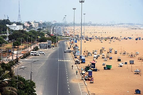
Chennai’s favourite outdoors recreational space is the Marina beach, which was artificially created when Chennai harbour’s breakwaters blocked the northward drift of sand along the shore. By 2050, when Chennai harbour is swallowed by the sea, the Marina will be under water. With the tide lapping at the steps of the state police headquarters, Chennai police will have bigger anxieties than having to deal with public protests on the beach. Many of our chief ministers who were laid to rest on the beach are likely to be disturbed if the model’s findings hold true.
Marina beach area in 2030, with moderate cuts in emissions and moderate luck. Image credit: www.climatecentral.org
Slide 4 (Uncertain Reliability):
Adyar’s southern bank houses the Besant Nagar beach, the fishing villages of Urur Olcott Kuppam and Odai Kuppam, the famous Velankanni church. The fishing villages are likely to be seriously affected. Most of the hip and happening tourist beach will disappear or be periodically flooded. One would need scuba gear to visit Schmidt Memorial and the Governor Bungalow. The famed church and the nearby Ashtalakshmi Temple too will take a beating.
Besant Nagar beach area in 2030, with moderate cuts in emissions and moderate luck. Image credit: www.climatecentral.org
Slide 5 & 6 (Good Reliability):
In the 2015 floods, one of the worst affected regions in Chennai was along the IT corridor. Built on low-lying areas of the Pallikaranai marshlands over the last 15 years, this area is destined to become a watery grave. What the rains did to remind Chennai of its hydrological offences by temporarily drowning homes, shops, malls and IT offices built on areas reserved for water, the sea will do by annual flooding events.
IT Corrdior in 2030, with moderate cuts in emissions and moderate luck. Image credit: www.climatecentral.org
The Sholinganallur ELCOT IT Special Economic Zone built over the Pallikaranai marshlands will witness ocean floods, unmindful of the fact that many of the IT offices have received Gold and Platinum certificates from international Green Building certifying agencies.
IT Corrdior in 2030, with moderate cuts in emissions and moderate luck. Image credit: www.climatecentral.org
The key conduit to conveying the deadly effects of Sea Level Rise through the length of the city is a much-celebrated Colonial era engineered water body called the Buckingham Canal. The IT Corridor used to be drained by the Buckingham Canal through the Kovalam Creek into the Bay of Bengal. In the era of climate change, everything reverses and the Bay enters through Kovalam Creek and the Buckingham Canal to flood the Pallikaranai.
Panic is not the answer. There is an urgent need for detailed ground-truthed high-resolution data on coastal elevation, particularly for urban centres along the coast. There is a crying need for acknowledgement by the government that the coast is vulnerable. This acknowledgement can come in the form of a declaration that areas already under tidal influence and known low-lying areas hydrologically connected to the sea will be No Development Zones.
(With inputs from K Saravanan, a fisher rights activist from Urur Kuppam)
Nityanand is a writer and social activist based in Chennai. Views expressed are author's own.