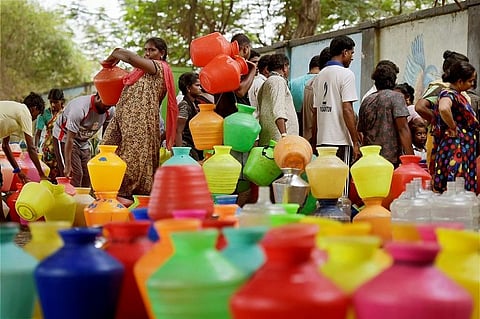
The severe water crisis that Chennai has witnessed this summer is perhaps its worst yet. The city’s reservoirs and lakes went dry, forcing a population of nearly 50 lakh into a drought-like situation. With major delays in the Tamil Nadu government finding alternative sources of water, private water tankers took to hiking prices, leaving citizens with no choice but to afford it or suffer. Even as the state continues to battle the ongoing crisis, it will need to introspect deeply and plan for the future if it hopes to minimise the effects of, or avoid a repeat. While the initial government denial of the crisis was unhelpful, the subsequent acknowledgement and willingness to seek help are positive signs for engagement and policy reform.
The crisis has been dubbed man-made for a variety of reasons ranging from unchecked development along the city’s water bodies, wanton mismanagement of resources by government agencies and a colossal failure in urban planning, among others. The city, with its cyclical flood and drought situation, is also perhaps the most visible example of the climate change crisis that the world is contending with. That the city and state administration have failed on this account is well documented. However, the now or never situation following the severe water crisis this season, should serve as a wake-up call for action.
Long-term approach
Professor Christoph Woiwode, Senior Lecturer in Human Geography at the Bath Spa University, agrees that at the current level of urban planning, the city will not be able to prepare and adapt to either flood or drought. In the aftermath of the December 2015 floods, Professor Woiwode’s research, along with that of his colleagues, showed the deluge was partly due to the change in land use plans by Chennai Metropolitan Development Authority (CMDA).
In an email interview with TNM, Professor Woiwode says, “We need to broaden the perspective beyond just urban planning. The key to a solution is governance for the entire metro region, which would involve interaction, coordination, and engagement of multiple and diverse stakeholders at different levels of implementation such as CMDA, TN state agencies (water board, DTCP, and others), local urban and rural authorities (Panchayats, MC Chennai), district administration, and so on. This is a complex task for which no mechanism has been developed so far. We have got technologies and engineering solutions to manage water and land use, but in order to generate a strategic and long-term approach to water and land use planning, corresponding governance and decision-making mechanisms are inevitable.”
Accounting for the city
Agreeing with him is Professor KP Subramanian, formerly of the Department of Urban Engineering, Anna University who points out that the master plans formulated for the city were “undertaken in isolation and there was no integration, whatsoever, between the urban planning on the one hand and infrastructure planning (ie water supply, sewer, and storm water drain), transport planning and physiographic planning (elevation of terrain, contour, slope, soil, land capability, rainfall, cyclonic storms, drainage and groundwater).
And this lack of planning and trampling of the city's physiography— its natural physical patterns and processes— has proved to be a disaster for Chennai.
Echoing the sentiment, Professor Woiwode says, “It appears that there has been quite some ignorance towards considering topographic aspects in the master plans. This dimension is especially important for new urban layouts and projected development areas on the outskirts of the city. We have studied some examples where we found that areas, in spite of having been identified as low-lying and flood risk prone, have been designated for residential development in the second master plan. In addition to this, the master plans are almost silent on addressing/discussing disaster risks (such as flooding, cyclones, droughts) and the response required from urban planning.”
Course correction
If there is one thing that residents and authorities must wake up to, following the crisis, it is the need for immediate action that looks beyond hoping for the North-East monsoon to bring rains.
Flagging the immediate areas of priority, Professor Subramanian says that in order to tide over the water scarcity, it is important to remove all encroachments, revamp the city's rainwater harvesting system, recycle waste water and ban the entry of sewage into storm water drains.
Professor Woiwode says, “There have been a number of attempts over the course of many years to redevelop the still existing lakes, ponds, water bodies in the city, and water harvesting has also become a legal requirement for new buildings (but must be stepped/scaled up much more). In my view, it is pivotal to look at the metro region and even beyond to understand the geo-hydrological interdependencies between the city and its ecological systems. An example of this in the current crisis, is the fact that water is brought in tankers from far outside the city (40-100kms away), creating potential depletion of groundwater levels in agriculturally important places and generating additional traffic volume. This is a highly unsustainable method of water supply. Course correction, hence, would involve a coordinated regional spatial strategy that protects ecologically sensitive areas (water drains, water bodies, and also flood retention areas, agriculturally valuable land), while at the same time designating land for potential development.”
