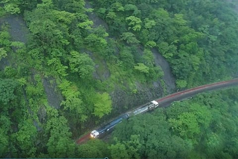
The South Western Railway (SWR) zone conducted an aerial survey of the Ghat section between Castle Rock-Kulem in Karnataka’s Uttar Kannada district using a drone camera, an official said on Wednesday, July 28. SWR hopes the aerial survey will help in identifying specific vulnerable locations in the area, which is already susceptible to landslides. “The drone mapping of vulnerable locations in the Castle Rock-Kulem Ghat section helps in taking preventive steps against landslides and water-logging on the tracks,” a SWR spokesman said in a statement.
The 27 km Ghat section on the Karnataka-Goa border is part of the rich bio-diverse Western Ghats, which receives heavy rainfall during the south-west monsoon from June-September every year. Castle Rock in the state’s northwest region is located in a heavily forested area, where vegetation is most tropical deciduous. The Ghat section has only a single railway line with no road connectivity.
“Steps have been taken to safeguard the tracks in the Ghat section, which is prone to land slips and water-logging. Embankment walls, sandbags and shoring up of side walls with sleepers have been put in place,” the official added.
As an additional safety measure, a drone camera was used to record a video of spots of water-logging on the hilltop, weak spots and loose boulders. “If any weak spot is noticed, a team of engineers, technicians and trackmen takes remedial action to prevent damage or blocking of the railway track,” the statement added.
The aerial survey is part of the SWR’s many inspections that started in the month of May, to identify locations that are prone to landslides and water-logging. Inspections were also done by foot to ensure the safety of the tracks. Sandbags, ballast, boulders, tools and equipment in monsoon wagons are kept ready at Castle Rock, Kulem and Tinaighat to attend to emergencies in the Ghat section.
Last week, two landslides had hit SWR’s Hubbali division, which left the parts between Dudhsagar – Sonaulim and Caranzol – Dudhsagar stations affected. In another incident, a landslide had affected National Highway 75 in the Shiradi Ghat section.