Bengaluru may have experienced its wettest year in over a century, but experts and activists say that the high amount of rainfall the city experienced in the last four months is not enough to account for the utter disarray that the city was thrown into.
For the record, 2017 was Bengaluru’s wettest year in 115 years, with the city receiving a record 1655.7mm of rainfall. The city’s administration was caught completely wrong-footed, as the heavy rains ripped the city’s roads apart, uprooted dozens upon dozens of trees, and killed sixteen people. Houses, domestic goods and vehicles in many parts of the city were also damaged as they were inundated with many feet of water following repeated heavy rains.

Even as officials blame the unprecedented rains, though, others say that such natural fury was only expected, as years of bad urban planning and management have set the stage for flooding in many parts of the city.
The worst-hit areas
According to data collected by the Karnataka State Natural Disaster Monitoring Centre, Koramangala’s ST Bed Layout, HSR Layout, Mahalakshmi Layout, Nayandahalli, the area surrounding HAL Airport, Jayanagar 1st block and Outer Ring Road were the worst hit areas. Many of these areas saw repeated flooding and inundation, with nearly every successive spell of heavy rains in the last four months.
In all these areas, a clear pattern of three factors play out in a troublingly similar pattern.
Boats at Koramangala
Firstly, each of these areas lies either on a lake bed or in the midst of a river valley.
Secondly, many of these areas fall on the wrong side of Bengaluru’s topography, lying in troughs that provide ideal collection points for all the excess rainfall.
And finally, many of these areas have seen significant encroachment on or misuse of the network of storm water drains that form the vital connections of Bengaluru’s lake and river network.
Bengaluru’s lost lake network
According to Shivakumar, Technical Engineer of the BBMP Storm Water Drains Department, “Koramangala’s ST Bed Layout, Ejipura, HSR Layout, the area surrounding HAL Airport and Jayanagar 1st Block all used to be lake beds. Among these, Koramangala was the worst hit. The entire locality is located in the Koramangala-Challaghatta valley. The area where the Challaghatta and Koramangala Lakes were once located has been converted into residential layouts.”
ST Bed Layout after the rain
While these areas most visibly showed the effects of being built on lake beds, this problem is pervasive across the city. According to records, an astounding 42 lakes have been emptied and their lake beds converted into residential localities or house important buildings or landmarks.
So, the Marenahalli Lake has been converted into Marenahalli Layout, while the Chinnagara Lake currently houses Ejipura Layout. Domlur second stage used to be the Dommaluru Lake, while Siddapura Lake is now Jayanagar 1st block. The Geddahalli and Nagashettihalli Lakes were wiped out to house the RMV 2nd stage layout. New Thippasandra Layout was built on the Kodihalli Lake. And Austin Town used to be the Sonnenahalli Lake, while HSR Layout was constructed on the Parangipalya Lake.
Several iconic structures in the city like the Kanteerava Stadium and Sai Hockey Stadium were also constructed on the Sampangi and Akkithimmanahalli tanks. The football stadium and some parts of the surrounding Ashok Nagar area have encroached up on the Shule Lake, while the National Diary Research Institute stands on the Koramangala Tank.
Not all of these areas may have suffered as badly as the six localities identified by the KSNDMC, says Ramprasad, convener of Friends of Lakes, an organisation of volunteers and experts working to revive lakes in Bengaluru. But every single of them saw at least one or more major episode of flooding or inundation in the last four months.
Encroachment on the Vrishabhavati River
Thanks to the inordinate attention given to bringing Bengaluru’s drinking water all the way from the Cauvery, what many Bengalureans do not realise is that Bengaluru sits amidst three smaller river basins of its own. Of these, the Vrishabhavati river flows directly through the city.
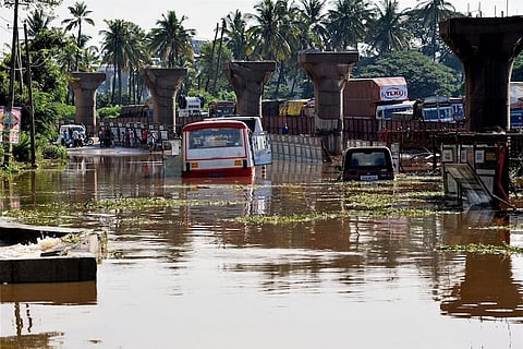
This monsoon, the city’s Nayandahalli experienced the full force of this forgotten river, and the area was repeatedly waterlogged and dozens of homes repeatedly flooded.
Watch: Woman stuck in a car in Nayandahalli after flood
The Vrishabhavati river, which arises on a small hillock near Bull Temple Road in Basavanagudi, flowing through Nayandahalli, Guddahalli, Raja Rajeswari Nagar and Kengeri before flowing into the outskirts of Bengaluru through Byramangala, Chowkahalli and Gopahalli to eventually join the Arkavathy river.
Ramprasad says that the once-pristine river that provided drinking water and livelihood to many in the neighbouring areas, has been converted into a massive sewage drain over the years. “The Bangalore Water Supply and Sewerage Board (BWSSB) connected all the sewer lines to the river and turned the river into a rajakaluve. Today, if you pass by Mysuru Road, you can see a frothing mass of water. That’s the river,” he says.
While Guddahalli and Kengeri escaped the Vrishabhavati’s fury by virtue of lying on higher slopes, Nayandahalli bore the brunt of it.
Raja Rajeswari Nagar too suffered some of the effects, though not as severely as Nayandahalli.
"According to law, you are not supposed to have constructions or human habitats in valley regions. There is a valley and there is a buffer zone. But we have encroached on the valley area itself. Of course water will collect in those areas," says Ramprasad.
Messing with the city’s topography
Hita Unnikrishnan, Assistant Professor of Conservation Science at TransDisciplinary University in Bengaluru, says that since Bengaluru is located on a semi-arid landscape – which makes it prone to drought – early planners capitalised on the elevated gradient of the city to maintain its water supplies. The depressions in the city's landscape were used to create a network of reservoirs, which were interconnected by storm water channels.
A 1792 map of Bengaluru
The idea behind this was to ensure that water could flow from one reservoir to another and create local water sources for the masses. These lakes and reservoirs were the primary water resource for the residents, Hita says. "This interconnected network also ensured that the lakes did not overflow their banks. The excess water in one lake could always flow out to another and that's how the waterlogging was kept in check," she adds.
But things began changing once these lakes, which were seasonal at the time, stopped being the primary source of water around the 1880s, and conservation of this network took a backseat.
“Essentially, the traditional drainage patterns of the city have remained the same but the channels have been built over," explains Hita.
Ramprasad concurs, pointing out that no city that is 3,000 feet above sea level and built along a ridgeline should be flooding. “In our arrogance, we do not respect the high and low contours, and think one naala (drain) will take care of everything. A place like Bengaluru should not flood. And if it is happening, there is something we are doing seriously wrong," he says.
A broken system of stormwater drains
It’s not just the lakes and rivers of Bengaluru that have been encroached upon. Just as vital to Bengaluru’s city-wide lake network are the rajakaluves or storm water drains that help circulate water throughout this system ensuring that no one place gets flooded by excess water.
Unfortunately, as Koramangala’s ST Bed Layout and many other areas found out, this system has been widely wrecked thanks both to encroachments and to the misuse of these storm water drains.
One of the clearest examples of this problem came from the Outer Ring Road, in the neighbourhood of the Savalkere or Saul Kere Lake. Though this area received just 2mm of rainfall on October 15, the following Monday morning saw the arterial road outside the RMZ Ecospace completely inundated.
According to Shivakumar, “Outer Ring Road is located in a low-lying area. This is important to note – Outer Ring Road has also encroached up on several storm water drains connecting the Savalkere Lake to Bellandur Lake. Hence, waterlogging happens here.”
Even where rajakaluves have not been directly encroached upon they’ve often been improperly turned into sewage disposal lines, adding a massive burden that these SWDs were never supposed to handle.
It comes as no surprise, therefore, that a large part of the SWD network in the city is completely clogged and unable to handle the kind of excess water flow required when the city is hit by heavy rains.
There are 633 interconnected storm water drains spanning a total of 842 km. Of this, primary SWDs run across 416km and the remaining 462km comprise of secondary SWDs. According to BBMP Engineer DS Suryanarayana of the Storm Water Drain Department, the BBMP has managed to desilt only 69km of SWDs so far.
What needs to be done
Hita points out that one of the main problems with lake conservation and other such efforts being carried out in Bengaluru is that they are too focused at the local level, while more systemic problems are ignored.
"When a Bellandur froths or catches fire, we focus on the individual lake without realising that there's a channel which connects it to a lake above and a channel which connects it to a lake below. The entire network needs to be looked into. Fixing a few random spots will not help," she says.
The authorities, for their part, now claim to be dealing with the problem at just such a system-wide level. Bengaluru Mayor Sampath Raj tells TNM that Rs 1,000 crore has been set aside by the government for this. Among the measures planned are the purchase of robotic desilting machines to clear much larger portions of the SWD network, a full separation of the sewage system and the SWD network by the BWSSB, the identification and removal of all encroachments on rajakaluves and the restoration of all of the city’s major lakes.
While Ramprasad agrees with the BBMP’s plans to reconstruct the storm water drains, the plan does not take into account the need to recharge the city’s groundwater instead of simply trying to funnel away rainwater, he says.
“Agreed that Bengaluru needs to redo its storm water drain system. But this Rs 1,000 crore project is just pointless because the SWDs will be constructed with concrete. These will not help in ground water recharge,” he says. Hita too agrees that the rainwater Bengaluru receives needs to be channelled towards open wells and other points where it recharges the groundwater.
At the policy level, Ramprasad adds, any ambitious plans to rework Bengaluru’s lakes and drainage system will require much more cooperation among various agencies. “The biggest problem is lack of interagency cooperation. All lakes from BBMP and BDA need to be transferred to one government body.”
Edited by Rakesh Mehar