Subhadra has lived in Wayanad, a district in north Kerala for more than 40 years. Her house is situated next to the Choondalipuzha river in Kabini basin. Subhadra and her family had to rush out at night on August 7 as the river entered their homes. It was a repeat of last year’s terror. But what this 60-year-old says clearly is that never before has she seen the wrath of nature so powerful.
“There used to be heavy rain before too, we used to shift to houses nearby and come back two days later. In the last 40 odd years, this is my first experience like this. We don’t even know where to go from this relief camp,” says Subhadra.
Subhadra’s words are echoed by many in relief camps across Kerala. In Malappuram, which was one of the worst-hit districts this year, Padmini says, “I have been living in Malappuram for 40 years since my wedding. I have never seen a flood like what happened in 2018 and 2019. Everything has been destroyed, only our lives have been spared.”
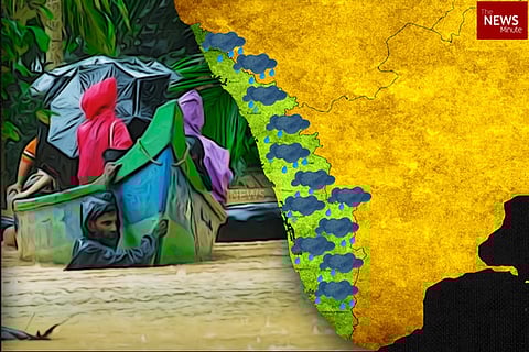
Kerala was staring at a huge rainfall deficit until August 1 this year. But between August 8 and August 14, the state witnessed extreme rainfall of 758 cm against the normal of 159 cm. That’s a whopping excess of 387%. A majority of this rain was focused on just four districts- Wayanad (70.7 cm), Kozhikode (68 cm), Palakkad (62.8 cm), Malappuram (59.4 cm).
The same time in 2018, the rainfall in Kerala between August 9 and August 15 was 403 cm against the normal of 144 cm. It was an excess of 257%.
So why has Kerala seen extreme rainfall in the past two years?
Experts say that monsoon patters are changing in India, with Kerala now seeing extreme rains in a short span as opposed to moderate rainfall spread over weeks. Research shows that two kinds of rainfall days are increasing: high rainfall days and low rainfall days.
At the same time, the number of moderate rainfall days has been decreasing.
This means that a whole season’s rainfall, which is normally spread across four months, is now coming down in a matter of days.
Watch:
Here’s the full transcript:
Subhadra has lived in Wayanad, a district in north Kerala for more than 40 years. Her house is situated next to Choondalipuzha, in Kabini basin, one of the major tributaries of the Cauvery river. Subhadra and her family had to rush out at night on August 7th as the river entered their homes. A repeat of last year’s terror. But what this 60-year-old says clearly is that never before has she seen the wrath of nature so powerful.
Subhadra, Wayanad resident: “There used to be heavy rain before too, we used to shift to houses nearby and come back two days later. In the last 40 odd years, this is my first experience like this. We don’t even know where to go from this relief camp.”
Across relief camps in Kerala, hundreds huddle together, wondering how to rebuild their lives. There is one thought everyone is echoing - no one has seen flood fury like this before.
Padmini, Malappuram resident: I have been living in Malappuram for 40 years since my wedding. I have never seen a flood like what happened in 2018 and 2019. Everything has been destroyed, only our lives have been spared.
Kerala was staring at a huge rainfall deficit until August 1 this year. But between August 8 and August 14, the state witnessed extreme rainfall of 758 cm against the normal of 159 cm. That’s a whopping excess of 387%.
A majority of this rain was focused on just four districts:
Wayanad 70.7 cm
Kozhikode- 68 cm
Palakkad- 62.8 cm
Malappuram- 59.4 cm.
The same time in 2018, the rainfall in Kerala between August 9 and August 15 was 403 cm against the normal of 144 cm. It was an excess of 257%.
Dhanya Rajendran, Editor-in-Chief, TNM: “The intense weather systems caused rivers to flood, leaving many districts under the mercy of the floods. So why has Kerala seen a sudden deluge in the past two years? It is clear that the monsoon patterns are changing.”
Kerala is now seeing extreme rains in a short span as opposed to moderate rainfall spread over weeks. Research shows that two kinds of rainfall days are increasing -high rainfall days
and low rainfall days. At the same time, the number of moderate rainfall days has been decreasing. This means that a whole season’s rainfall, which is normally spread across four months, is now coming down in a matter of days.
Pavan Srinath, public policy researcher: “What is happening is that the number of days you have extreme rainfall, say 10cm, that is going up in frequency. What this means is that when there is no disaster, these rains are not as useful for agriculture because most of the rains is run-off rather than staying in the soil because the same rainfall happens over multiple days. Apart from that, what happens is that the kind of disasters we are seeing now two years in a row, the likelihood increases.”
Anna Isaac, Deputy News Editor, TNM: “Several scientists attribute this change in monsoon patterns to global warming. They point out that the Pacific Ocean, which has been absorbing heat due to increasing carbon emissions, has in turn been dumping its heat into the Indian Ocean. With the Indian Ocean becoming warmer, this in turn has impacted the monsoon winds.”
Venu G Nair, Meteorologist, Centre for Earth Research and Environment Management: “Unusually they have seen that the Pacific Ocean is dumping huge amount of heat to the Indian Ocean. Normally scientists are calling it ocean heat content. Earlier, the ocean heat content was surface to 200 metre or so. Now it has been stretched to 2km. You can imagine Indian ocean is so rich with heat content, it will definitely transfer to atmosphere and the atmosphere will use this energy for its dynamic purposes.”
The atmosphere creates rain-bearing clouds, resulting in extreme spells of rainfall.
Venu Nair, Meteorologist, Centre for Earth Research and Environment Management: “So with this warming scenario, the atmosphere is capable of holding more water vapour than earlier. So in a plain language we can say that, earlier when we will be getting rain, maybe 10 raindrops will there. In an extreme event, maybe 100 raindrops you will be getting from a cloud. Because the atmosphere is capable of holding more water vapour as well as ocean is supplying more water vapour to atmosphere. So both are actually feeding clouds. So that has been changed.”
And while extreme rainfall is one reason for the deluge, Kerala’s unique topography and narrow rivers contribute immensely to the scale of the disaster.
James Wilson, special officer, Kerala govt: “Kerala has a peculiar topography. It is a very narrow strip of land. It has steep slopes. As a result, the entire rainwater, from the Western Ghats to the sea, reaches in 24 hours. If have heavy localized rainfall in the Ghats…From the catchment area, the water will reach the river in a small time of 3-4 hours. Kerala rivers are very narrow compared to other rivers in country like Godavari, Krishna or Cauvery. So your Periyar will breach – if you have 300-400mm rainfall.”
More than the deluge, it is the big landslides that wreaked havoc in Kerala. One of the biggest factors for the floods and landslides is the unrestrained development, with environmental norms severely diluted. Kerala, like its neighbours, has refused to accept the report by ecologist Madhav Gadgil which recommended designating the entire Western Ghats as an Ecologically Sensitive Area, and restricting mining, quarrying and construction in these fragile lands.
Sridhar Radhakrishnan, activist: “What last year’s rains, floods and landslides have taught us is this is a fragile land and you cannot do a Dubai in Kerala. And all politicians, bureaucrats, all over the place upto the CM of kerala have this notion that kerala can develop like what they all dream. And unfortunately, all their dreams are Dubai dreams or Middle East dreams. It just doesn’t happen like that. We have to learn to live with the fragility. We have to learn to manage our landscapes and learn to live in fragile landscapes.”
Other experts say that though the monsoon pattern has changed, extreme rainfall and floods would have to recur again in the next ten years for it to be labelled climate change. To study any of this, the need of the hour is real-time weather data.
Pavan Srinath, public policy researcher: “Though the relationship between climate change and monsoon is quite difficult to understand, what we need is the ability to measure the weather on a day to day basis much better. We need probably one weather station automated, that is sending its data live online probably every 30 sq km in a place like the Western Ghats, in Kerala and Karnataka. Because rainfall changes from one side of the hill to another. So we need to have a real-time understanding of how much rainfall is happening in an area, and this uses weather stations, satellites. And then feed that information to people who are managing our dams, catchment areas, various public centres and so on so that action can be taken far more quickly.”
After decades of changing land use patterns, and destroying forests, what’s certain is that there may be no going back. With over 500 dead and lakhs displaced from the two consecutive disasters, it’s now about the lessons we learn.