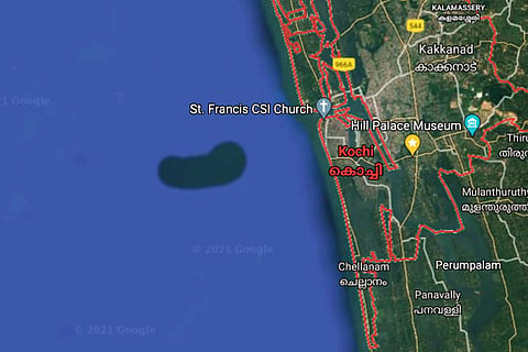
The puzzling satellite image from Google Maps that showed a bean shaped formation in Arabian Sea near Kochi coast, could possibly be an error and not really an island or underwater island formation, many experts have said. Reports of a peculiar formation being detected in Google Maps’s satellite imagery had recently gone viral. TNM had earlier reported that the Kerala University of Fisheries and Ocean Studies (KUFOS) in Kochi has decided to conduct a study to find the phenomenon. However, many other experts have taken to social media, stating that the ‘phenomenon’ is possibly a technical glitch or error and that there could be no other possibilities for this.
Speaking to TNM, Harilal Madhavan, faculty at the Indian Institute of Science Education and Research (IISER) at Thiruvananthapuram, states that there are multiple reasons to conclude that the phenomenon is a technical glitch. “Firstly, we have to note that this particular formation is only visible in Google Maps satellite imagery, but in the default (terrain view), this is not visible. If it really would have existed, it should be visible in the terrain view of the Google Maps,” says Harilal.
Secondly, he added that when zoomed, parts of the ‘formation’ shown in Google Maps looks like the image has been assembled. “In one corner of the ‘formation’, some images appear to have blended together. Thirdly, when we zoom more into the map, oil tankers and ships can be seen. We can even see the trail left behind by a moving ship. If this is an underwater sediment, movement of ships through this region is questionable. Altogether this looks like an error,” Harilal added.
Arjun Gangadharan, a geospatial expert based in Kerala, in his blog has detailed that the phenomenon could have happened due to “errors.. in the backend algorithm of Google Maps.” He also adds that the particular area might have appeared highlighted as a high resolution imagery could have been replaced on the spot.
“If you analyse the Google maps satellite view, it is evident that the land masses have a high resolution satellite imagery and the Ocean after a 1.3km (approximate) is replaced with ocean bed replica textured images. In the case of an island, only the island land mass with a standard buffer area will be available in high resolution image, the rest will be the same ocean floor. Here in the case of our ‘island’ google satellite view instead of ocean bed texture, high resolution imagery has been replaced. This might be due to the errors happened in the backend algorithm of Google maps. The high resolution image creates an illusion of an island as it stands out from the surrounding texture,” Arjun says in his blog.
Raj Bhagat P of the World Resources Institute (India) in a Twitter thread also has a similar opinion. “The artefact near Kochi is because high resolution satellite images have been provided for that section instead of ocean floor graphic. It is not an island just that the visual is different. In fact if you zoom in you can see ships moving around in the area claimed to be sea,” he states in his tweets.
Multiple news outlets published an article based on a social media post that a new underwater island has been spotted in Google Maps near #Kochi. It is a visual artefact and not an island. Read tweets below
— Raj Bhagat P #Mapper4Life (@rajbhagatt) June 18, 2021
The news/post/mystery holds no water (pun intended)
1/4 pic.twitter.com/6qan8arHuV
Meanwhile, in his blog, Arjun has also posted various other high resolution satellite images including Landsat 8, Bing imagery, Maxar Technologies’ Maxar Premium layer, etc, which shows no such formation. He has also included images of turbidity levels in the region and 3D images of bathymetry data (showing underwater depth of ocean floors). He states all these show no peculiar formations in the region.
Supporting the view, Thiruvananthapuram-based social scientist Vishnu Unnikrishnan also states that if it was really an island formation, objects like stone could be detected. “When we examine similar looking small islands, while zooming in, we can see there are some objects inside these formations. But here nothing of that sort is visible,” he adds.
However, speaking to TNM, fishers in the region stated that they had been observing the presence of heavy siltation in a large area, five kilometers away from the Kochi coast. “Over the past four months, even before this Google Map image became viral and came to our notice, we had been feeling a difference. There is heavy siltation resembling clay in the area. While fishing in this area, our fishing nets are getting stuck in the clay-like sediment. It is so hard to pull out that we have to cut off the net, ending up damaging it,” says PS George, a fisherman based in Kochi and also the former President of Palluruthy Block Panchayat. He also adds that fishers are observing increased fish availability in the spot.
Read:
