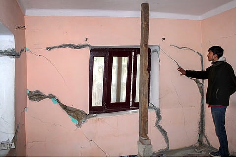
Joshimath, a small town in Uttarakhand, has come under the spotlight as huge cracks have developed in buildings and structures there. The Indian Space Research Organisation (ISRO) has released satellite images of the pilgrimage town, showing that it sank at a rapid pace of 5.4 cm in just 12 days. Disaster relief teams have reached the site and have begun airlifting residents of the town. While safety issues around the subsidence of Joshimath were raised as early as the 1960s, the issue made headlines in the first week of January, when large cracks started appearing on the walls of buildings in the town. Subsequently, the town was declared as a ‘landslide and subsidence-hit zone’.
According to reports, as many as 678 homes in Joshimath had developed cracks and became unfit for residing as of January 9. Local authorities had shifted 81 people to temporary relief centres. Further, alternate arrangements were also made for 4,000 people in Joshimath and the nearby Pipalkoti. So, where is Joshimath and what is happening there?
Joshimath is an ancient pilgrim town located in Chamoli district of Uttarakhand, and is at an elevation of around 1,875 metres above sea level. It is the gateway to several famous pilgrimage centres including Badrinath and Hemkund Sahib, and also to the international skiing destination Auli and the Valley of Flowers, a UNESCO World Heritage site. Pilgrims and tourists enroute to these places halt in Joshimath, which has also helped create employment opportunities there. In 1962, Joshimath became a place of ‘strategic importance’ due its location between the India-China border.
However, Joshimath has always remained in a geographically vulnerable position due to four main reasons:
> The town is built on deposits from an older landslide. In 1976, the Union government had appointed an 18-member committee under the then collector MC Mishra to look into why Joshimath was sinking. The committee conducted ground surveys at the time, and submitted a report saying that Joshimath lay on the debris of an ancient landslide which was a “deposit of sand and stone — not the main rock”. The report also stated that it was not suitable for township and “vibrations produced by blasting, heavy traffic, etc., will lead to a disequilibrium in natural factors”.
> Joshimath is located in a Zone-V seismic zone, which means it is at the highest risk of encountering an earthquake. In India, land is classified into four seismic zones — Zone-II, Zone-III, Zone IV and Zone V. While Zone-V is the most seismically active region, Zone-II is the least.
> Joshimath also lies between two thrusts. A thrust is defined as a break or crack in the Earth's crust, where the older rocks are pushed above the younger rocks.
> Joshimath also faces threats due to extreme weather conditions, as it lies in a place where high-intensity rainfall might trigger landslides.
These factors, combined with unchecked human activity and growth, are believed to be responsible for the sinking of Joshimath. Further, hydroelectric projects including the Tapovan Vishnugad Hydro Power Plant in nearby Chamoli district threaten the town’s stability.
In 1976, experts warned to stop developmental works in ecological fragile region of Joshimath, Uttarakhand. Today Joshimath is sinking. And thousands of people are now become homeless.
— Licypriya Kangujam (@LicypriyaK) January 7, 2023
When humans will stop ecological destruction ? You will pay the price to your children. pic.twitter.com/JfTjMa47GH
Early in 2021, a massive landslide occurred when a glacier broke off in Joshimath and caused a massive flood in the Dhauli Ganga river. Later, in October, 14 families in the Chhawani Bazar locality noticed cracks in their houses, prompting them to use wooden poles as structural support. However, similar cracks soon started appearing all over the town.
According to a report on Joshimath published by the Uttarakhand State Disaster Management Authority (USDMA), floods in June 2013 and February 2021 increased land erosion in the region. Further, the very heavy rains in October 2021 (190 mm within 24 hours) ‘worsened the subsidence and vulnerability to landslides’. According to the National Oceanic and Atmospheric Administration (NOAA), “land subsidence is a gradual settling or sudden sinking of the Earth’s surface.” It can be caused due to multiple factors, including “removal of water, oil, natural gas, or mineral resources out of the ground by pumping, fracking, or mining activities” or “earthquakes, soil compaction, glacial isostatic adjustment, erosion, sinkhole formation”.
However, it was in the 1960s that the buildings in Joshimath first developed cracks. It was only after this that the Mishra Committee was appointed. The Committee’s recommendations included “developing a pucca drainage system in the town to stop seepage of rainwater, avoiding digging at slopes and collecting construction material in the five-kilometre vicinity, and a ban on chopping trees to prevent landslides”.
Satellite images of Uttarakhand's Joshimath released by ISRO show that the Himalayan town sank at a rapid pace of 5.4 cm in just 12 days, triggered by a possible subsidence event on January 2. The preliminary study by ISRO's National Remote Sensing Centre (NRSC) said the land subsidence was slow between April and November 2022, during which Joshimath had sunk by 8.9 cm.
According to a preliminary observation by ISRO, the entire town of #Joshimath might sink as a result of rapid land subsidence. The holy town sank 5.4 cm in a period of just 12 days! Central part of Joshimath town, army helipad and Narsingh Mandir are witnessing rapid subsidence. pic.twitter.com/qEvqRAFID8
— Harsh Vats (@HarshVatsa7) January 12, 2023
But between December 27, 2022 and January 8, 2023, the intensity of land subsidence increased and the town sank by 5.4 cm in these 12 days, according to the report. The pictures were taken from the Cartosat-2S satellite. "The region subsided around 5 cm within a span of a few days and the aerial extent of subsidence has also increased. But it is confined to the central part of Joshimath town," the NRSC report said.
Sharing images of the site, the report said that a subsidence zone resembling a generic landslide shape, with a broad base and tapered tip. The report noted that the crown of the subsidence was located near Joshimath-Auli road at a height of 2,180 metres. The images show the Army Helipad and Narsingh Temple as the prominent landmarks in the subsidence zone that spans the central part of Joshimath town.
So why is Joshimath sinking? Is it due to the natural and geographical factors alone? The impending disaster in Joshimath is caused by a combination of geographical factors and an unchecked construction spree in recent years. Due to increased tourist activity and pilgrims swarming the town, authorities began constructing more buildings and hotels for economic growth.
Two man-made projects that allegedly worsened the situation are the construction of a road to Badrinath and a project by the National Thermal Power Corporation Limited (NTPCL). The existing Badrinath road was widened as part of the Char Dham (Four Pilgrimage Centres) road widening project. According to a report in Third Pole, trees were being cut and natural water channels were choked as the roads were constructed against the “government’s own principles on how to build a road in a mountain area”. The six-kilometres-long Helang-Marwari bypass is part of the 825-km Char Dham highway expansion project in Uttarakhand.
Meanwhile, the Tapovan-Vishnugad hydro power project of the NTPCL is said to be a run-of-the-river electricity generation project. It includes boring a tunnel over 12 km in length through the hillside, through which water from the Dhauli Ganga river can be channeled to generate electricity.
For 26 months when I was Environment Minister, I grappled with the development-environment issue in Uttarakhand. In a vast majority of cases, I decided in favour of ecological protection. This didn’t win me many friends, but these visuals from Joshimath vindicates my position. pic.twitter.com/4UYvgJJbiX
— Jairam Ramesh (@Jairam_Ramesh) January 7, 2023
Meanwhile, local residents and the opposition Congress have blamed the building of the NTPCL hydropower project tunnel and the construction of the Char Dham all-weather road for “aggravating” the land subsidence problem in Joshimath. However, NTPCL — which is a state-owned power producer — said that the tunnel did not pass below Joshimath but under Auli, and that the tunnel of its Tapovan Vishnugad hydel project has nothing to do with the landslides in Joshimath. It is to be noted that it was in this project that around 200 workers were killed in a flash flood in February 2021.
> About 169 families consisting of 589 members have, so far, been shifted to relief centres.
There are 835 rooms serving as relief centres in Joshimath and Pipalkoti in Chamoli, which together can accommodate 3,630 people. There are 16 places in Joshimath where temporary relief centres have been built for the affected people. Apart from them, 19 more hotels, guest houses and school buildings have been identified for the affected people in Joshimath and 20 outside the town in Pipalkoti.
> An interim assistance of Rs 1.5 lakh has been paid so far to each of the 42 affected families.
> Uttarakhand Chief Minister Pushkar Singh Dhami has said that a committee would be appointed to decide the market rate for compensation to be paid to the affected families by “keeping in mind the interests of stakeholders”.
> The Uttarakhand High Court, while hearing Public Interest Litigations (PIL) filed about the crisis, directed that an order banning construction activities in the areas surrounding Joshimath be passed immediately.
> The Uttarakhand Chief Secretary, earlier this week, said that “every minute is important” as more houses, buildings and roads developed cracks in the sinking town of Joshimath. Following this, red crosses were placed on hundreds of unsafe structures.
> The district administration asked the occupants to either shift to the temporary relief centres or rented accommodation, for which each family will get assistance of Rs 4,000 per month for the next six months from the state government. However, many residents stayed on in their homes despite the imminent danger.
> It has been decided to "mechanically remove" two hotels — Mount View and Malari Inn — in Joshimath, which have been badly affected by land subsidence.
> The Congress has demanded that the land subsidence situation be declared a national calamity. They also called for all developmental projects in the area to be halted till a report by experts and environmentalists is submitted on the issue.
> Labelling it as a man-made disaster, the opposition party sought the government to enhance compensation for each house affected due to the "unbridled development" in the area. It asked the government to preserve the old Joshimath town and develop a new town to rehabilitate the residents. Congress president Mallikarjun Kharge said, "Protect nature. The whole country is worried and is with the people of Joshimath, where unbridled development has created cracks in Uttarakhand's 'Devsthal'."
"We have three demands from the Modi government — The Joshimath tragedy should be declared a ‘national calamity’; stop all new projects, including railways and hydel power, until a newly appointed high-level committee of experts, scientists, environmentalists and local people submits its report; the oustees of Joshimath be given adequate compensation from PM CARES fund, instead of only Rs 5000," he said in a series of tweets in Hindi.
> Former Uttarakhand chief minister Harish Rawat also demanded that the compensation given to each victim of the disaster be increased to Rs 50,000, and that a “new Joshimath” be established while preserving the old town.
