This story is among several stories from TNM that will highlight the inundation, flooding and other consequences of heavy rains in Hyderabad. TNM hopes to draw attention to these issues, which have now become perennial in many areas of the city, by talking to experts, officials and more.
From the distance thou didst appear
barricaded in rocky aloofness
Timidly I crossed the rugged path
to find here all of a sudden
An open invitation in the sky
and friends embrace in the air
In an unknown land the voice that
seemed ever known
Revealed to me a shelter of loving intimacy’.
These were the words of Rabindranath Tagore, in his poem ‘Kohsar,’ written during his visit to Hyderabad’s Banjara Hills in 1933, where the Durgam Cheruvu is located. Historians said that he was so fascinated by the natural beauty of the area, that if he didn't have his Viswa Bharati to care for, he said he would have liked to settle down here. Until a few decades ago, Durgam Cheruvu was in a secluded and picturesque location, surrounded by green pastures and shielded by rocks that are said to date back to more than 2.5 billion years ago. As per the Telangana government’s own website, “the reason behind this intriguing name is indistinct, but old timers assert that for many years, the lake remained hidden as there were no roads to reach the place and it was well kept away from naked eye. (sic)”
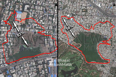
Initially catering to the drinking water needs of the Qutb Shahi dynasty and residents of the Golconda fort, today, it is in the heart of Hyderabad’s IT sector and home to the city’s first ever hanging bridge. Satellite images from 1967 and now, accessed by TNM in collaboration with Raj Bhagat P and Aakash Malik of the World Resources Institute (India), of Durgam Cheruvu and four other lakes, show the extent of how many water bodies in Hyderabad have fallen prey to urbanisation and slowly decreased in size over the years. And the images are shocking, to say the least.
The Durgam Cheruvu which had water spread over 4.7 lakh sq m in 1967, has reduced in size by over 15%, and is only 4 lakh sq m in 2021. (Swipe, or toggle the bar in the centre to see the before and after versions of the lake)
The Mir Alam Tank, located adjacent to the Hyderabad zoo, saw its area of water spread decrease by almost 23% — from 18.8 lakh sq m in 1967 to 14.5 lakh sq m in 2021.
The historical Shah Hatim Talab located in Golconda decreased by 58%, from 3.8 lakh sq m to 1.6 lakh sq m in the same time period.
The Gurram Cheruvu meanwhile shrunk by almost 55% — from 3.3 lakh sq m to 1.5 lakh sq m in this period.
However, the worst was the Ramanthapur Cheruvu, which saw its area shrink by over 83% — from 1.2 lakh sq m to a measly 20,000 sq m.
These lakes didn’t shrink overnight. According to some studies, between 1989 and 2001, the city lost 3,245 hectares of water bodies — about 10 times the size of Hussain Sagar. Dr Anjal Prakash, Research Director, Bharathi Institute of Public Policy at the Indian School of Business highlights that across south India, and especially Telangana, the tank management system involved a cascading system of lakes.
“More than 90% of these lakes were built artificially and carved out using the topography and they were all interlinked. Once water filled up in any of the tanks, it would fill up the tanks located at a lower level and eventually drain out. Various dynasties understood and maintained the same system. When the British came, they didn't understand the system very well and they brought in the canal system because that's what they knew from the European understanding. That superseded the earlier system because the two systems were different,” he says.
During and since the IT boom in Hyderabad, Anjal says, “The nexus of local politicians, land mafia and the builders lobby came together to systemically appropriate the land as it was available free of cost. The small nalas or feeder channels were lost and the water bodies became independent, unlike how they were part of a larger interconnected system earlier. These lakes had the capacity to absorb water, but that was lost.”
There are two major components when it comes to lakes — Full Tank Level (FTL) and Buffer Zone. An FTL is the maximum amount of water that the tank or lake is designed to hold. Any excess water drains out through a surplus weir. However, since the draining happens slowly, the water body can expand beyond the FTL, and this stretch is known as the Buffer Zone.
Anant Maringanti, the Executive Director of Hyderabad Urban Lab says that the nature of urban property has dramatically changed. “In the buffer zone and upto the FTL, you are not supposed to build anything permanent. This buffer zone is gone for all of the tanks, because successive governments have been too fixated on the FTL. In the FTL too, in the summer, water recedes and the Nizam government used to give pattas (title deeds) for seasonal cultivation for OBCs and SCs. Those have all been converted now into property.”
“On the ground level, corruption is a very complicated story. A lot of poor people who could not afford land anywhere else, do occupy these places and slowly claim some rights and documentation,” he adds.
Anant also points out how a lot of water has been pumped into Hyderabad from the Krishna and Godavari basins over the last few years. “All your city's daily needs for water are coming from outside the city. Your drain and tank system within Hyderabad is meant for the precipitation here. You're bringing water from somewhere outside and a large part of that is also going into this system,” he says, detailing the reasons for the repeated flooding in the city.
“It becomes difficult to predict exactly where you'll have a problem. When the flooding happens, you mitigate the issue temporarily if the people who are affected are important enough. The main lens through which you're looking at it is encroachment, which doesn't work as a tool,” he adds.
"The fundamental cause behind most of the urban flooding in Deccan cities like Hyderabad or Bengaluru is the construction and built up expansion along valleys and floodplains which are supposed to be natural water conduits. As asphalt and concrete surfaces increase, they reduce percolation into soil. Combined with the loss of the natural valley drains, over concretisation has been resulting in increased flood incidents. All the modern lakes and tanks were built across these natural valleys for different purposes but as urbanisation started they could have been repurposed as recharge points and as buffers to store excess rainwater and regulation of the same. However a good number of lakes have their capacity reduced by means of encroachment, sewage storage, and over siltation,” says Raj Bhagat P of the World Resources Institute (India).
Governments too, have not done much to address the issue. A report by the Comptroller and Auditor General of India (CAG) in 2018 found that even the first step to tackle the issue — surveying the lakes in the city, was incomplete. It also pointed out that the Lake Protection Committee (LPC) under the Hyderabad Metropolitan Development Authority (HMDA) did not have statutory powers to enforce its decisions.
“HMDA had submitted an action plan for conservation and beautification of 258 lakes to the state government. Neither the approval nor release of funds was received from the government, as a result of which the action plan could not be implemented. HMDA did not spend any amount on conservation and protection of lakes, except an amount of Rs 12.62 crore on survey of lakes during the last five years i.e. 2013-18,” the report stated.
Mentioning Durgam Cheruvu in particular as a case study, the CAG found, “Continuous encroachments in the catchment, buffer area and the FTL of lakes coupled with inaction on the part of the Revenue Department to remove encroachments resulted in deterioration of lake health and threatened the very existence of the lake.”
It also noted lack of coordination between various agencies and departments of the government.
Anjal suggests two solutions to the issue: “The immediate suggestion would be to demarcate all the land and protect water bodies with their present capacity as removing encroachments often gets caught up in litigation. We should first save the water body that is already there. This is not very difficult to do if the government has political will.”
“Secondly, wherever these channels that link lakes together exist and are working, there is a need to recognise, clean and protect them, so the interconnectedness between the various water bodies remains. Wherever lakes have become independent, rain water harvesting systems should be introduced,” he explains.
“Our cities also lack meaningful scientific approaches with respect to the designs and maintenance of artificial storm water drains which is adding to the woes. Our cities should start working on a roadmap with detailed drainage plans and strategies which incorporate nature based solutions and other methods to reduce and compensate the effects of rapid unplanned urbanisation,” says Raj Bhagat.
Anjal agrees: “Urban planning has been devoid of environment planning. They have not gone hand in hand. We have to base our urban planning on natural resources, in this case, the natural flow of water. Protect this first and build your cities. It would be far more sustainable that way.”
Old Images: Corona Program (NARA, USGS EROS); Processed by Aakash Malik, WRI India.
New Images: Google, Maxar Technologies.
