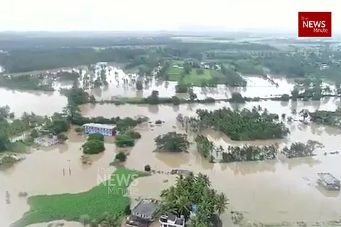

Once known for serene hilly landscapes, eye-catching coffee estates and its sacred groves, Kodagu is now in ruins. One of the smallest districts in Karnataka, where the River Cauvery originates from, the entire district is now reeling from the disaster caused by rains, multiple landslides and incessant flooding. Twelve people have been killed, thousands have lost their homes, entire villages have caved in or have been submerged.
According to the Indian Meteorological Department (IMD), Kodagu has received a total of 2732.5 mm rainfall since June this year. This is double the annual average rainfall during the monsoon which is pegged at 1738 mm. Last week alone, the district witnessed 508.2 mm rainfall compared to last year's 130.3 mm. Activists say that although the rainfall witnessed this year is double the annual average, they point to the gradual destruction of the environment for the widespread havoc.
The last time such a disaster was witnessed in the state was in 1961, environmentalists say.
Was the disaster that has unfolded in Kodagu, in many ways, waiting to happen?
Illegal sand mining and destruction of safety ridges
According to rescuers who were part of the District Disaster Management Team, which was engaged in carrying out rescue operations, the landslides occurred in areas where sand mining had weakened the ridges which kept rain water at bay.
“There are several ridges along the buffer zone of River Cauvery where illegal sand mining has been going on. This has made the embankments weak and they were unable to withstand the heavy water flow when the river swelled up. The catchment areas flooded and people were stranded. Areas like Kudumangalore (near Harangi Dam), Hattihole and Mukkodlu were the worst hit. The embankments were weakened by illegal sand mining and they broke loose, which resulted in flooding,” one of the rescuers told TNM.
Speaking to TNM, Colonel Cheppudira Muthanna, President of the Coorg Wildlife Society says that both sides of the Harangi River have been encroached by people either for farming purposes or for sand mining. “The sand dunes are there for a reason on the river banks. Many people have built homes and begun agricultural activities in the buffer zone. Besides, there is massive sand mining, which is ignored. The sand dunes have disappeared over the years. These villages were bound to flood at some point. So many of us warned the government that this would happen but no one listened,” Colonel Muthanna says.
Rampant deforestation for tourism and infrastructure development
Kodagu’s landscape comprises of dissected and moderately sloping structural hill ranges. Some of the hillocks in the region have sharp ridges and steep slopes too. “The topography suggests that the steeper and higher slopes are susceptible to landslides. Earlier, these slopes were covered with thick green cover. This ensured that soil erosion was minimal and the occurrence of landslides were minimal,” Colonel Muthanna says.
Over the past week, multiple landslides have destroyed coffee estates, homes and entire villages have caved in and activists say that the rampant construction of hillside homestays and jungle lodges have resulted in deforestation, which had caused the landslides to occur.
“The rocks in the hilly areas are porous. In 2014, over 50,000 trees were chopped off to construct a powerline between Karnataka and Kozhikode. Now, the government is planning to chop off lakhs of trees for construction of multi-lane highways. Apart from this, over the past few years, many trees on the hillslopes and forest areas were cut to construct homestays, resorts and jungle lodges. Apart from this, there is also the problem of timber smugglers and over the years, they have destroyed Kodagu’s landscape,” alleges Dr Cheppudira Kushalappa, Dean of the Forestry College in Kodagu.
Colonel Muthanna maintains that despite efforts of local activists to stop the deforestation activities, the government has turned a blind eye. “In the 2030 masterplan for Kodagu, the government has suggested that Madikeri town be expanded to three times its size. This will come at a high cost of deforestation. Currently, the reason for the landslides is because of the rampant terracing of hillslopes by cutting trees. If more trees disappear, there will be nothing to act as a barrier for soil erosion and it will lead to more flooding and more landslides every time it rains,” he added.
Over the last 10 years, about 2,800 acres of coffee plantations and paddy fields in Kodagu have been converted for commercial purposes. Towns in Kodagu have rapidly expanded to give rise to new layouts which have been constructed in between the towns. The layouts also expand and towns start to join each other and become larger towns. “This is bad because these areas were forest lands, which were home to various species of medicinal plants. Now they are being destroyed,” he added.
Local activists lament the government’s decision to destroy sacred forest land to construct national highways. The estimated cost is pegged at destruction of 3 lakh trees in Kodagu, which is a bio diversity hotspot.
Currently, geologists and soil scientists are taking stock of the situation in Kodagu and are trying to determine the exact cause of the landslides. However, Dr Kushalappa says that based on preliminary inspection, the soil from the landslides had landed in the river streams and tributaries of River Cauvery, which has caused major flooding in Madikeri area.
"The mud has blocked the course of water, forcing the diversion of streams. This has resulted in water entering low lying areas and flooding," he added.