The Indian Space Research Organisation (ISRO) on Wednesday created a world record by successfully putting 104 satellites into orbit.
The Indian rocket Polar Satellite Launch Vehicle (PSLV) lifted off successfully with 104 satellites, including the country's earth observation satellite Cartosat-2 series, from the Sriharikota spaceport in Andhra Pradesh on Wednesday morning.
The co-passenger satellites comprised 101 nano satellites, one each from Israel, Kazakhstan, the Netherlands, Switzerland and the UAE and 96 from the US, as well as two nano satellites from India.
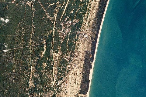
Of all the satellites injected into orbit, 88 belong to an American company called Planet. Planet offers geo-imaging services and these satellites, called "Doves" were part of its Mission 1: the ability to image all of Earth’s landmass every day.
Virtually every part of the Earth's surface can now be photographed every day.
"In 2011 we set ourselves the audacious mission of imaging the entire Earth land area every day. We were convinced that armed with such data, humanity would be able to have a significant positive impact on many of the world’s greatest challenges. We calculated that it would take between 100-150 satellites to achieve this, and we started building them. After today’s launch, Planet operates 144 satellites in orbit. We have reached our milestone," Planet wrote on its website.
Geo-imaging can have many applications- for example in the field of agriculture- which can be used by governments, researchers, organisations.
Happy to report that all of the 88 Doves are happy, healthy, and rotating in real-time! pic.twitter.com/4xe8vWZnJr
— Planet (@planetlabs) February 15, 2017
Mike Safyan, Planet's director of launch and regulatory affairs, explained to Mashable how the images can be used to track and maybe even control deforestation.
"If we have an update of an area every six months, you can see change but there's not much you can do about it. Whereas, if every day, you're getting an alert where trees are going down, where they aren't, allowed to be harvested or cut down, then you can actually go and send someone and do something about it," he said.