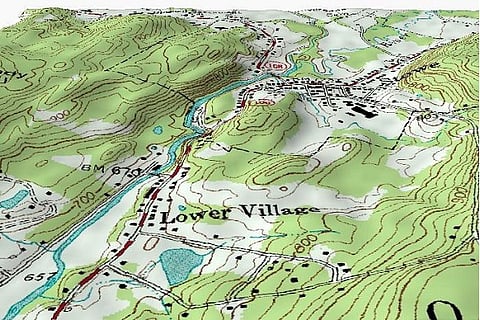
Union Science and Technology Minister Harsh Vardhan on Monday launched a new web portal - Nakshe Portal - providing free download of Survey of India's topographic maps of the entire country in PDF format to Indian citizens.
The topographic maps on the scale of 1:50,000, contain natural and man-made geographical features including terrain or topography. The service was launched to mark the 250th anniversary of the Survey of India.
"Earlier, these maps were only available after a process of application... Now it's on the fingertip of people... it would be a great help for infrastructure development, science and education," said Ashutosh Sharma, Secretary, Department of Science and Technology.
The maps would be made available free through Aadhaar-enabled user authentication process in line with the Digital India programme of the government, the minister said.
According to a report in the Hindustan Times, these maps include natural and manmade geographical features, topographic maps are 3-D because they capture the heights of features.
The Survey of India also launched a new model called the Geoid model. This is to adjust GPS measurements of height to get the above mean sea level (AMSL) data, which is the standard measure of height.
"The Survey of India has proposed to re-measure the height of Mount Everest... India was the first country under Sir George Everest's leadership to have declared the height of Mount Everest in 1855,” he said.
"After Gorkha earthquake (Nepal earthquake) in 2015, to answer various doubts of scientific community, the Survey of India proposed re-measuring the height of Mount Everest as an Indo-Nepal Joint Scientific Exercise, along with the Survey Department of Nepal," the minister added.
“It will empower people to get data they need at their fingertips,” said Sharma, he illustrated with an example of a gram panchayat which wanted to take up a local developmental project, according to the HT report. So far, they would have to submit applications and pay fees. Even government agencies had to pay for these maps.
With inputs from IANS
Image: Kbh3rd